


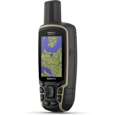

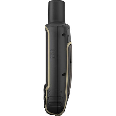
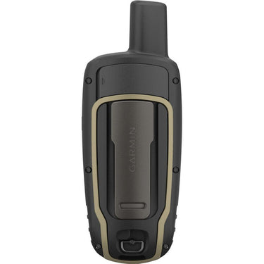
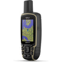


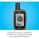

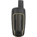
Garmin GPSMAP 65 Handheld Outdoor GPS Navigator Multi-Band/Multi-GNSS
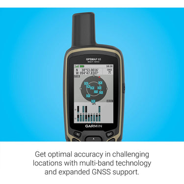
- Multi-Band GNSS for Optimal Accuracy
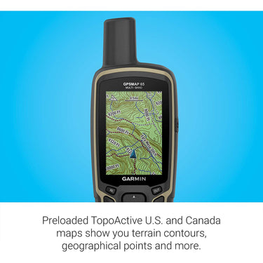
- US & Canada Routable Topo Maps
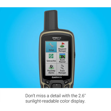
- 2.6" Sunlight-Readable Color Display
- Receive Alerts from Your Phone
 Garmin GPSMAP 65 Handheld Outdoor GPS Navigator Multi-Band/Multi-GNSS
Price unavailable
Garmin GPSMAP 65 Handheld Outdoor GPS Navigator Multi-Band/Multi-GNSS
Price unavailable

Pickup currently unavailable at 80 Carter Drive
Your payment information is processed securely. We do not store credit card details nor have access to your credit card information.
What's In The Box
- Garmin GPSMAP 65 Handheld Outdoor GPS Navigator
- TopoActive North America U.S. & Canada Maps
- USB Cable
- Carabiner Clip
- Limited 1-Year Garmin USA Authorized Dealer Warranty
Free Shipping
Free ground shipping is available to home addresses in the contiguous United States. PO Boxes, Alaska, Hawaii, US Territories (including Puerto Rico), APO/FPO and addresses outside the United States are not eligible for free shipping.
FedEx Shipping
All merchandise except for oversized items (e.g. Flat screen LED TVs over 55" and plasma TVs over 51") advertised on Beachcamera.com are usually shipped via FedEx.
All packages shipped from Beachcamera.com require a signature upon delivery. Please arrange for someone to sign for the delivery if you are unable to do so. We recommend that you provide an email address so that we may keep you informed of the status of your order and send you tracking information. You will be able to track your order online or by phone for an estimated time of arrival. FedEx will attempt to deliver your package three times before returning it to Beachcamera.com
United States Postal Service (USPS) Shipping
Small items such as memory cards may be shipped by the Post Office.
If the destination address is a PO Box or an APO/FPO, we will ship your order via USPS since FedEx is unable to deliver to those destinations. We will provide tracking information via email after your order has shipped. Items delivered to a PO Box or an APO/FPO will be delivered in 7 - 10 business days. Final delivery for APO/FPO destinations will be subject to the Terms and Conditions of the APO/FPO services. Not all items can be shipped via USPS. Some items that are shipped via USPS may be subject to an additional shipping charge. If necessary, Beachcamera.com will contact you before the order is processed.
Oversized Merchandise Shipping
Oversized merchandise (Flat screen LED TVs over 55", plasma TVs over 51", BBQ Grills & Furniture) are shipped via a motor freight carrier that specializes in Home Delivery. Since these items are large and fragile, special handling is required, and cannot be shipped via our standard shipping options.
We take every precaution during our shipping preparation process to ensure that your order arrives to you in perfect condition. Each item on your order is scanned for accuracy of model and serial number. We apply large orange fragile sticker labels to notify the carrier that your shipment is fragile and requires special handling. The labels also include important step-by-step instructions on how to inspect and sign for your shipment. In addition to the manufacturer's standard foam and corrugated packaging, we also apply a special shock absorption polyethylene material to the outer carton of every TV. This safeguard will disperse energy from impact during transit, and eliminate damage to the product itself. Our professional appointment-based delivery service allows you to open and inspect your new TV prior to signing and accepting the TV. When you purchase a TV at Beachcamera.com, you can be sure that it will arrive perfect working order, and will remain that way for a long time to come.
Non-Deliverable Addresses
We are unable to delivery to the following addresses:
- Mail box drop off locations
- Hotels and motels
- Trade Shows, Conventions, Conferences
Standard Return Policy
We want you to love the items you purchase from Beachcamera.com. If you are not satisfied with your purchase for any reason, you may return items for a full refund within 45 days, subject to the conditions below.
- Returned merchandise must be in original condition and include all factory packed accessories and paperwork (e.g. battery, charger, cords, straps, unmarked warranty card, manuals, etc.), in the original manufacturer box and packaging with UPC, barcode, and serial number intact.
- Incomplete returns will receive a reduced credit, reflecting any missing peripherals.
- The product serial number must match the serial number in our database. Beachcamera.com maintains serial number tracking.
- We require that all approved returns of computers, tablets, and similar devices have the password removed or restored to the system default.
- Return merchandise must be double-boxed with no writing on the manufacturer's box. Your Return Authorization number should be prominently displayed on the outside of the shipping box.
You must contact our customer service department to arrange a return. All returns must be shipped to the following address:
BTC Beach Camera Returns
80 Carter Drive
Edison, NJ 08817
You must include the RA number issued to you by customer service, please be sure to write this number clearly on the return box.
Please be sure to save the shipment tracking number for your return. Merchandise lost or damaged during shipping is the shipper's responsibility.
Televisions over 65" must be returned via one of our Home Delivery Partners. Please contact us to schedule a pickup for your large TV return.
If your return is not the result of our error, the return shipping costs are the responsibility of the customer.
Television Returns
Buyer's Remorse for TVs in Brand New condition:
If you are not 100% satisfied with your TV purchase, you may return it within 30 days from delivery for a full refund, less return shipping fees. Please note that a 15% restocking fee may apply. All returned TVs must be in their original box and include all packing material, manuals, and accessories.
Damages:
We're here to help!
For Common Deliveries (FedEx, UPS):
Please inspect the TV and report any damages (e.g. cracked screen, scratches, dents, etc.) within 2 days by contacting us at 1.800.572.3224
For Special Handling/Freight deliveries:
Please open and inspect the TV prior to signing for it. If the TV is cracked or damaged, please refuse delivery and contact us immediately at 1.800.572.3224 .
Please note damage claims will be denied for the following:
- TVs with over 60 minutes of recorded usage
- TVs that have been moved from the original delivery address
All damage claims must be made within two (2) days of delivery. We will issue a refund and cover all shipping costs.
Manufacturer Defects:
Your TV is fully covered under your in-home one year Manufacturer's Warranty service. If any further assistance is needed, please contact us. *Open-Box units are covered under our in-house 90 day warranty.
Drones Returns
All defects can be handled under the manufacturer's warranty. For DJI brand drones, call DJI at 818-235-0789 and obtain a case number for the defect prior to requesting an RMA. Please note only Dead on Arrival units out of the box will be returnable to us (with a valid case number). DJI will NOT authorize any returns to us if there are any signs of use like dirt, grass stains, nicks or any signs of use. For these situations, the Return Authorization would need to be handled directly between the customer & DJI
Exceptions
- Mattresses
- Opened or Downloadable Software
- Consumables, including batteries, paper and ink
- Opened packages of Apparel, Bedding or Linens
- Used Cookwear and BBQ Grills
- Personal Body Massagers/Shavers
- Special order items
- Refunds
Refunds for returns are applied to the payment method used at the time of purchase. Once we receive and inspect the product we will credit your account. Please allow 5-7 business days for a credit to appear on your account.
Product Exchanges
If you purchased a product from Beachcamera.com that you wish to exchange for an alternative, you can return the item for a full refund and simply place a new order for the item you desire. A refund credit cannot be applied to a new purchase.
Defective Items
An item that was discovered to be defective upon receipt can be replaced or returned for a full refund.
Damage or Missing Items
Claims for items damaged in transit or missing items must be received within two business days of receipt of the shipment.
Replacement
We will send a product replacement after the authorized return has completed our receiving/inspection process. The replacement will ship within four business days following the receipt of your return. Please allow for additional processing time after holidays.
Although it is our goal to ship a replacement as quickly as possible, a replacement cannot be shipped before we receive and inspect the return. To receive a replacement more quickly, you may place a new order for the same item (shipping not included) and we will issue a refund for the full value of the returned product (including shipping) upon completion of our return process.
Product Details
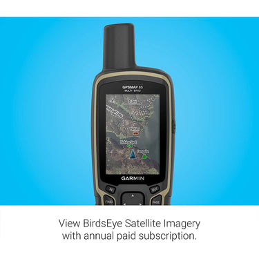
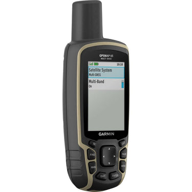
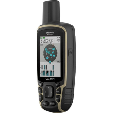
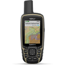
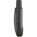
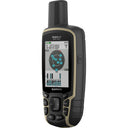
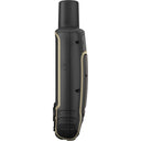
Find your way in this big, wide world with GPSMAP 65. This rugged handheld offers multi-band technology and expanded GNSS support for optimal accuracy in steep country, urban canyons and forests with dense trees. It has a 2.6” color display and button-operated design. Wireless connectivity through BLUETOOTH and ANT+ technologies provides compatibility with the Garmin Explore™ website and app (compatible smartphone required) to help you manage tracks, routes and waypoints and review statistics from the field.
EXPANDED GNSS SUPPORT
Multi-band technology and expanded GNSS support (GPS, GLONASS, Galileo, QZSS and IRNSS) provide optimal accuracy in steep country, urban canyons and forests with dense trees.
PRELOADED TOPO MAPS
Preloaded TopoActive U.S. and Canada maps show you terrain contours, topographic elevations, summits, parks, coastlines, rivers, lakes and geographical points.
PUBLIC LAND BOUNDARIES
An optional display of federal public land boundaries on topographical maps helps you know that you’re venturing where you’re supposed to be.
SMART NOTIFICATIONS
Receive emails, texts and alerts right on your handheld when paired with your compatible smartphone
Features
- Pre-loaded with TOPO U.S. and Canada maps
- Utilizes GPS, GLONASS, Galileo, QZSS, and IRNSS global navigation satellite systems for accurate positioning, even in dense cover and urban canyons
- microSD slot for adding finely detailed Garmin Topo 24K and HuntView Plus maps
- Plan, review, and sync waypoints, routes, and tracks by using the Garmin Explore app and website
- 2.6" sunlight-readable display
- Bluetooth and ANT+ connectivity
- IPX7-rated water resistant
- Smart notifications from compatible phones and devices
- Live Tracking
- Hunt/fish calendar
- Sun and moon information
Garmin GPSMAP 65 Specs
| Application | Education, Forestry, Geocaching, Hiking, Trekking, Hunting, Land Survey, Orienteering |
| Track Log | 10,000 Points, 200 Saved Tracks |
| Battery Type | Internal (Rechargeable) |
| Runtime | Internal (Rechargeable): 16 h |
| Display Size | 2.2 x 1.4" / 5.59 x 3.56 cm, Diagonal Size: 2.6" / 6.6 cm |
| Display Type | Color |
| Internal Memory | 16 GB |
| Memory Card Slot | 1 x microSD |
| Waterproof Rating | IPX7 |
| Bluetooth | Yes |
| Backup Camera Compatible | No |
| Touchscreen | No |
| Camera | No |


